Ice warning for North East as Met Office issues alert over freezing temperatures
and live on Freeview channel 276
The Met Office already has an alert in place today, Tuesday, January 5, and has now issued another, which will continue on from 4pm today until 11am tomorrow, with the warning covering from Edinburgh down to the south of Nottingham.
It warns icy surfaces will lead to difficult travel conditions in places and urges caution, as some injuries could result from slips and falls on icy surfaces.
Advertisement
Hide AdAdvertisement
Hide AdIt also says people should beware of icy patches on untreated roads, pavements and cycle paths.
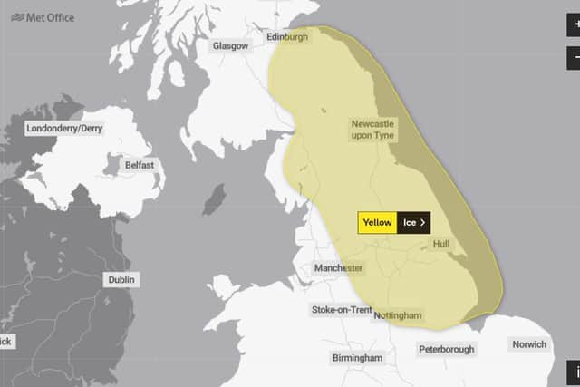

The warning says: “Wintry showers are likely to persist on Tuesday night, and as ground temperatures fall below freezing, ice is likely to form on untreated surfaces.
"Some wet snow may fall to low levels at times well inland but any settling will mostly be confined to high ground.
"Between 2cm and 5cm snow is likely above 250 metres, and perhaps up to 10cm in a few places above 400 metres over the north Pennines.”
Advertisement
Hide AdAdvertisement
Hide Ad
The region’s Met Office forecast predicts a bitterly cold night with showers continuing through the night, especially for coastal parts.
Showers will turn wintry over high ground with a risk of snow and ice, with northeasterly winds easing.
The temperature could drop as low as -5C.
Tomorrow, a breezy start is expected with showers continuing from the North Sea, these wintry over high ground and Becoming drier later as winds fall light.
There could be patches of freezing fog overnight with a maximum temperature of 3C.