Storm Eunice aftermath: North East recovers from impact of high winds
and live on Freeview channel 276
The weather system brought strong gusts across the region, with snow on higher ground, as Met Office forecasters issued a Yellow warning for the North East.
While the alert has now ended, more windy weather was forecast across the weekend.
Advertisement
Hide AdAdvertisement
Hide AdStorm Eunice brought damage to buildings, as well as disruption to road, rail, air and ferry services.
The clean-up operation continued in some parts of the region on Saturday, February 19. See how the day unfolded with a recap of our updates.
Storm Eunice aftermath: Region recovers from impact of high winds
Key Events
- Clean-up continues after damage and destruction from Storm Eunice on Friday, and Storm Dudley earlier this week
- Windy weather expected throughout the weekend - but no Met Office weather alerts for North East
- What the forecast says for the half-term break across the region
Updated Met Office warnings
Met Office forecasters have updated previously-issued Yellow warnings for wind, which will take effect on Sunday and Monday. The North East could be in line to escape the worst, according to the current forecast shown here.
More damage in Sunderland from Storm Eunice
The Ford Lodge apartments in South Hylton have been damaged as a result of yesterday’s high winds. Emergency services were pictured at the scene, alongside debris on the ground. Many thanks to Simon Walker for sending in the photograph.


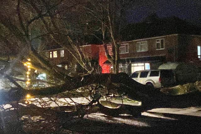
Lancaster Road, Hartlepool
The week’s high winds caused damage across the region, with this fallen tree pictured by our photographer Frank Reid in Lancaster Road, Hartlepool. While the weather is expected to be blustery in the coming days, the North East is not yet subject to any further warnings from the Met Office.
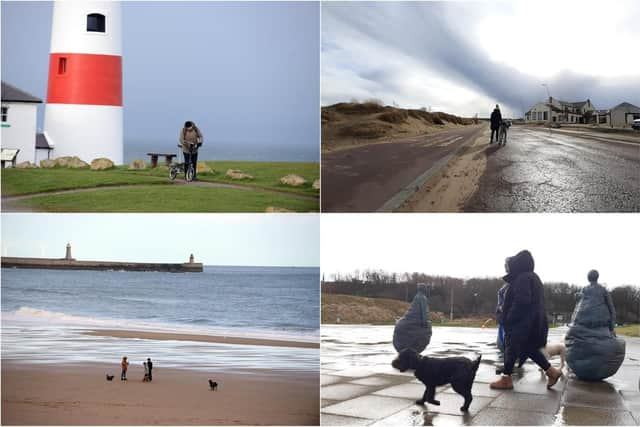
Friday recap: Feeling the chill across South Tyneside on Friday
Our photographers were out and about on weather watch this week, with Stu Norton capturing this collection of pictures from South Tyneside on Friday.
🌟 Event given go-ahead for tonight
Did you have plans to attend North of the Tyne, Under the Stars this evening? Well, we have some good news! It’s been confirmed that this evening’s sessions in Blyth and North Shields are going ahead.
🗣 Update on Storm Eunice clean-up
Sunderland City Council has issued an update on its ongoing clean-up operation following Storm Eunice on Friday.
Council Leader, Cllr Graeme Miller said: “We’ve had council teams on standby throughout both storms ready to support communities and deal with any storm damage. They’ve done a brilliant job responding to calls about dangerous buildings and fallen trees in some pretty challenging weather conditions to keep our communities safe and I can’t thank them enough.”
The northern section of Fawcett Street is expected to remain closed until Monday at least, while a separate closure of the eastbound lane of the A183 Chester Road at the end of Croft Avenue also remains in place.
The council statement added: “The city council understands the strategic importance of both these busy routes within the city’s road network and is working to ensure they are reopened as soon as it is safe to do so.”
🤔 What does the weather forecast say for Sunday?
While the Met Office has issued Yellow alerts for other areas on Sunday (February 20), the North East doesn’t yet have one.
We take a look at what forecasters are expecting for Saturday evening, heading into Sunday, across the North East.
The weather will remain windy as we start a new day, with heavy rain expected in the morning.
And while it may be mild early doors, it’s due to turn chilly later with a minimum temperature of 2 °C by around 9pm.
Highs of 11 °C are expected during the day.